Brookfield night lights from space
Night Light of Brookfield (Wisconsin) from space (United States) Src. Average luminocity for 10x10km area is 78.3968% and for 50x50km: 46.2444%.
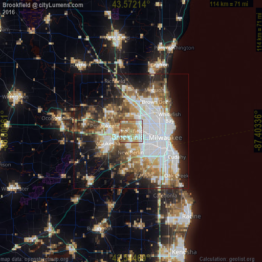

Analysis of Brookfield night lights 2016
Square area 10x10 km:
 19.52%
90-99
18.89%80-89
5.87%70-79
14.13%60-69
27.3%50-59
13.65%40-49
0.48%30-39
0.16%20-29
0%10-19
0%0-9
0%Square area 50x50 km:
14.38%90-99
8.19%80-89
4.28%70-79
4.59%60-69
6.42%50-59
6.44%40-49
6.19%30-39
5.1%20-29
8.73%10-19
12.33%0-9
23.37%Clear (daylight) street map image can be seen on geolist.org.
Map coordinates:
43° 34' 19.7" North, 88° 48' 34.6" West
43° 3' 38.1" North, 88° 6' 23.3" West
42° 32' 40.9" North, 87° 24' 12.1" West
Some cities around Brookfield sort by population:
• Waukesha
11.5 km =7.1 mi,  241°
241°
• West Allis
9.4 km =5.8 mi,  121°
121°
• Wauwatosa
8.1 km =5 mi,  98°
98°
• New Berlin
9.4 km =5.8 mi,  180°
180°
• Menomonee Falls
13.2 km =8.2 mi,  356°
356°
• Sussex
12.4 km =7.7 mi,  310°
310°
• Pewaukee
12.8 km =8 mi,  280°
280°
• Elm Grove
3 km =1.9 mi,  131°
131°
5246835 (p: 38,025)
Sources (retrieved 2019-11-25):
» Earth at Night: Flat Maps 2012, 2016