Branson night lights from space
Night Light of Branson (Missouri) from space (United States) Src. Average luminocity for 10x10km area is 56.0256% and for 50x50km: 7.533%.
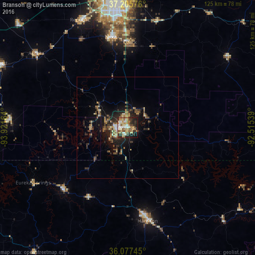
Analysis of Branson night lights 2016
Square area 10x10 km:
 8.42%
8.42%90-99
10.62%80-89
8.79%70-79
10.44%60-69
8.61%50-59
10.26%40-49
5.86%30-39
10.07%20-29
13.74%10-19
11.17%0-9
2.01%Square area 50x50 km:
0.46%90-99
0.78%80-89
0.98%70-79
0.99%60-69
1.14%50-59
1.25%40-49
1.13%30-39
2.25%20-29
2.46%10-19
5.55%0-9
83.01%Clear (daylight) street map image can be seen on geolist.org.
Map coordinates:
37° 12' 20.7" North, 93° 55' 17.9" West
36° 38' 37.2" North, 93° 13' 6.6" West
36° 4' 38.8" North, 92° 30' 55.4" West
Some cities around Branson sort by population:
• Springfield
64 km =39.8 mi,  353°
353°
• Nixa
45 km =28 mi, 351°
• Ozark
42 km =26.1 mi,  1°
1°
• Republic
57.9 km =36 mi,  336°
336°
• Harrison
47.1 km =29.3 mi,  167°
167°
• Aurora
57.5 km =35.7 mi,  309°
309°
• Battlefield
54.2 km =33.7 mi, 345°
• Berryville
44 km =27.3 mi,  225°
225°
4378219 (p: 11,431)
Sources (retrieved 2019-11-25):
» Earth at Night: Flat Maps 2012, 2016