Bliss Corner night lights from space
Night Light of Bliss Corner (Massachusetts) from space (United States) Src. Average luminocity for 10x10km area is 46.1818% and for 50x50km: 12.0536%.
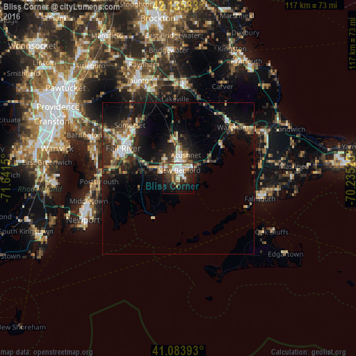
Analysis of Bliss Corner night lights 2016
Square area 10x10 km:
 10.88%
90-99
9.42%80-89
4.38%70-79
6.49%60-69
5.52%50-59
2.76%40-49
7.95%30-39
7.63%20-29
10.06%10-19
20.62%0-9
14.29%Square area 50x50 km:
1.5%90-99
1.81%80-89
1.32%70-79
1.1%60-69
1.41%50-59
1.78%40-49
1.77%30-39
2.23%20-29
4.39%10-19
9.61%0-9
73.08%Clear (daylight) street map image can be seen on geolist.org.
Map coordinates:
42° 8' 7.2" North, 71° 38' 29.4" West
41° 36' 42.4" North, 70° 56' 18.1" West
41° 5' 2.1" North, 70° 14' 6.9" West
Some cities around Bliss Corner sort by population:
• New Bedford
2.8 km =1.7 mi,  19°
19°
• Fall River
20.6 km =12.8 mi,  298°
298°
• Fairhaven
4.1 km =2.5 mi,  45°
45°
• Head of Westport
10.3 km =6.4 mi,  275°
275°
• Acushnet
8.1 km =5 mi, 18°
• Freetown
18.9 km =11.7 mi,  335°
335°
• Mattapoisett
11.4 km =7.1 mi,  62°
62°
• Marion
17.6 km =10.9 mi, 56°
4930804 (p: 5,280)
Sources (retrieved 2019-11-25):
» Earth at Night: Flat Maps 2012, 2016