Acushnet night lights from space
Night Light of Acushnet (Massachusetts) from space (United States) Src. Average luminocity for 10x10km area is 49.3279% and for 50x50km: 15.7115%.
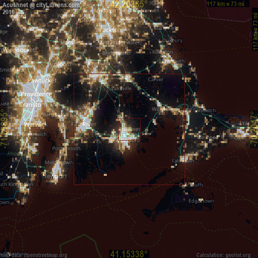
Analysis of Acushnet night lights 2016
Square area 10x10 km:
 10.71%
90-99
12.01%80-89
6.33%70-79
4.22%60-69
6.82%50-59
7.79%40-49
2.76%30-39
7.14%20-29
12.01%10-19
18.67%0-9
11.53%Square area 50x50 km:
1.8%90-99
2.51%80-89
1.84%70-79
1.57%60-69
1.9%50-59
2.31%40-49
2.26%30-39
3.12%20-29
5.05%10-19
12.13%0-9
65.5%Clear (daylight) street map image can be seen on geolist.org.
Map coordinates:
42° 12' 13.1" North, 71° 36' 39.4" West
41° 40' 50.4" North, 70° 54' 28.2" West
41° 9' 12.2" North, 70° 12' 16.9" West
Some cities around Acushnet sort by population:
• New Bedford
5.3 km =3.3 mi,  197°
197°
• Fall River
20.7 km =12.9 mi,  276°
276°
• Fairhaven
4.8 km =3 mi,  175°
175°
• Head of Westport
14.4 km =8.9 mi,  242°
242°
• Freetown
14.1 km =8.8 mi,  312°
312°
• Mattapoisett
8 km =5 mi,  107°
107°
• Bliss Corner
8.1 km =5 mi, 198°
• Marion
12.2 km =7.6 mi,  79°
79°
4928720 (p: 10,850)
Sources (retrieved 2019-11-25):
» Earth at Night: Flat Maps 2012, 2016