Birch Bay night lights from space
Night Light of Birch Bay (Washington) from space (United States) Src. Average luminocity for 10x10km area is 7.9844% and for 50x50km: 15.6817%.
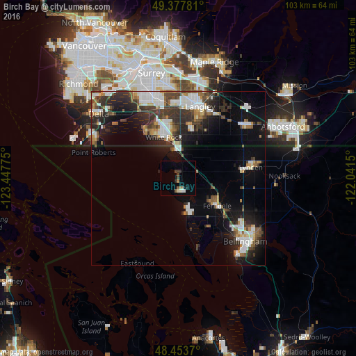
Analysis of Birch Bay night lights 2016
Square area 10x10 km:
 0.57%
0.57%90-99
1.14%80-89
1.14%70-79
0%60-69
1.14%50-59
1.14%40-49
1.7%30-39
1.14%20-29
0.57%10-19
1.14%0-9
90.34%Square area 50x50 km:
3.07%90-99
3.18%80-89
1.12%70-79
1.29%60-69
1.44%50-59
1.69%40-49
2.27%30-39
3.59%20-29
4.51%10-19
8.68%0-9
69.15%Clear (daylight) street map image can be seen on geolist.org.
Map coordinates:
49° 22' 40.1" North, 123° 26' 51.9" West
48° 55' 4.4" North, 122° 44' 40.6" West
48° 27' 13.3" North, 122° 2' 29.4" West
Some cities around Birch Bay sort by population:
• Surrey, CA
21.8 km =13.5 mi,  344°
344°
• Bellingham
25.7 km =16 mi,  133°
133°
• White Rock, CA
11.7 km =7.3 mi, 338°
• Langley, CA
21.3 km =13.2 mi,  17°
17°
• Lynden
21.6 km =13.4 mi,  81°
81°
• Ferndale
13.8 km =8.6 mi, 125°
• Aldergrove, CA
25.3 km =15.7 mi,  52°
52°
• Blaine
8.4 km =5.2 mi,  358°
358°
5787316 (p: 8,413)
Sources (retrieved 2019-11-25):
» Earth at Night: Flat Maps 2012, 2016