Baychester night lights from space
Night Light of Baychester (New York) from space (United States) Src. Average luminocity for 10x10km area is 90.0714% and for 50x50km: 79.7829%.
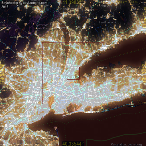
Analysis of Baychester night lights 2016
Square area 10x10 km:
 54.25%
90-99
20.07%80-89
2.04%70-79
7.82%60-69
7.48%50-59
2.89%40-49
4.25%30-39
1.19%20-29
0%10-19
0%0-9
0%Square area 50x50 km:
38.42%90-99
16.78%80-89
6.27%70-79
8.52%60-69
10.67%50-59
5.3%40-49
3.05%30-39
3%20-29
2.72%10-19
3.34%0-9
1.92%Clear (daylight) street map image can be seen on geolist.org.
Map coordinates:
41° 23' 55.9" North, 74° 32' 22.5" West
40° 52' 9.4" North, 73° 50' 11.2" West
40° 20' 7.6" North, 73° 7' 60" West
Some cities around Baychester sort by population:
• The Bronx
3.3 km =2.1 mi,  229°
229°
• Parkchester
3.9 km =2.4 mi,  210°
210°
• Wakefield
3.4 km =2.1 mi,  337°
337°
• Unionport
4.8 km =3 mi,  193°
193°
• Van Nest
3.3 km =2.1 mi,  224°
224°
• Morris Park
2.4 km =1.5 mi, 217°
• Woodlawn
4.1 km =2.5 mi,  321°
321°
• Pelham Manor
3.8 km =2.4 mi,  40°
40°
5108186 (p: 16,274)
Sources (retrieved 2019-11-25):
» Earth at Night: Flat Maps 2012, 2016