Baraboo night lights from space
Night Light of Baraboo (Wisconsin) from space (United States) Src. Average luminocity for 10x10km area is 20.9286% and for 50x50km: 5.4591%.
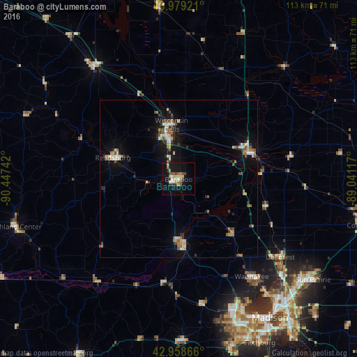
Analysis of Baraboo night lights 2016
Square area 10x10 km:
 2.06%
2.06%90-99
2.54%80-89
3.49%70-79
3.33%60-69
3.17%50-59
1.9%40-49
2.86%30-39
3.02%20-29
2.22%10-19
21.11%0-9
54.29%Square area 50x50 km:
0.5%90-99
0.63%80-89
0.82%70-79
0.79%60-69
0.71%50-59
0.65%40-49
0.75%30-39
0.65%20-29
0.86%10-19
4.35%0-9
89.29%Clear (daylight) street map image can be seen on geolist.org.
Map coordinates:
43° 58' 45.2" North, 90° 26' 50.7" West
43° 28' 15.9" North, 89° 44' 39.4" West
42° 57' 31.2" North, 89° 2' 28.2" West
Some cities around Baraboo sort by population:
• Madison
52.3 km =32.5 mi,  147°
147°
• Sun Prairie
53.5 km =33.2 mi,  126°
126°
• Middleton
45.9 km =28.5 mi, 154°
• Waunakee
38.8 km =24.1 mi,  143°
143°
• Portage
23.9 km =14.9 mi,  71°
71°
• Reedsburg
21.9 km =13.6 mi,  288°
288°
• De Forest
40.8 km =25.4 mi, 127°
• Mount Horeb
51.4 km =31.9 mi,  179°
179°
5244638 (p: 12,155)
Sources (retrieved 2019-11-25):
» Earth at Night: Flat Maps 2012, 2016