Bala-Cynwyd night lights from space
Night Light of Bala-Cynwyd (Pennsylvania) from space (United States) Src. Average luminocity for 10x10km area is 93.3776% and for 50x50km: 80.3736%.
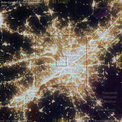
Analysis of Bala-Cynwyd night lights 2016
Square area 10x10 km:
 45.58%
90-99
30.44%80-89
6.63%70-79
9.35%60-69
7.99%50-59
0%40-49
0%30-39
0%20-29
0%10-19
0%0-9
0%Square area 50x50 km:
25.25%90-99
18.36%80-89
11.19%70-79
13.8%60-69
14.61%50-59
9.38%40-49
4.55%30-39
2.58%20-29
0.28%10-19
0%0-9
0%Clear (daylight) street map image can be seen on geolist.org.
Map coordinates:
40° 32' 38.6" North, 75° 56' 13.9" West
40° 0' 27.4" North, 75° 14' 2.7" West
39° 28' 0.9" North, 74° 31' 51.4" West
Some cities around Bala-Cynwyd sort by population:
• Philadelphia
8.6 km =5.3 mi,  135°
135°
• Center City
8.9 km =5.5 mi,  134°
134°
• Drexel Hill
8.4 km =5.2 mi,  216°
216°
• Ardmore
4.4 km =2.7 mi,  268°
268°
• Yeadon
7.8 km =4.8 mi,  193°
193°
• Lansdowne
8.4 km =5.2 mi,  202°
202°
• Penn Wynne
4.3 km =2.7 mi,  235°
235°
• Wyndmoor
9 km =5.6 mi,  24°
24°
5178892 (p: 9,299)
Sources (retrieved 2019-11-25):
» Earth at Night: Flat Maps 2012, 2016