Wyndmoor night lights from space
Night Light of Wyndmoor (Pennsylvania) from space (United States) Src. Average luminocity for 10x10km area is 89.5731% and for 50x50km: 77.6308%.
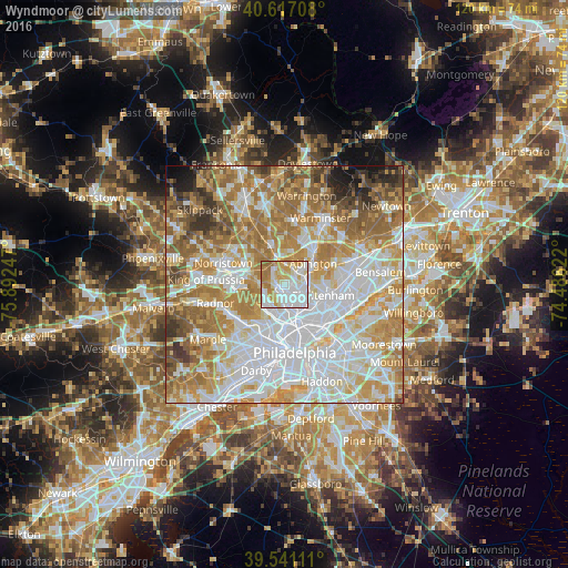
Analysis of Wyndmoor night lights 2016
Square area 10x10 km:
 36.69%
90-99
24.51%80-89
13.15%70-79
13.15%60-69
11.36%50-59
1.14%40-49
0%30-39
0%20-29
0%10-19
0%0-9
0%Square area 50x50 km:
24.29%90-99
17.25%80-89
10.84%70-79
13.35%60-69
14.47%50-59
7.82%40-49
4.51%30-39
3.23%20-29
2.07%10-19
1.86%0-9
0.33%Clear (daylight) street map image can be seen on geolist.org.
Map coordinates:
40° 37' 1.5" North, 75° 53' 32.9" West
40° 4' 52.4" North, 75° 11' 21.6" West
39° 32' 28" North, 74° 29' 10.4" West
Some cities around Wyndmoor sort by population:
• Willow Grove
9.4 km =5.8 mi,  41°
41°
• Bala-Cynwyd
9 km =5.6 mi,  204°
204°
• Glenside
3.9 km =2.4 mi,  53°
53°
• Ambler
8.6 km =5.3 mi,  341°
341°
• Plymouth Meeting
7.6 km =4.7 mi,  287°
287°
• Oreland
4.3 km =2.7 mi,  13°
13°
• Dresher
6.9 km =4.3 mi,  16°
16°
• Fort Washington
6.9 km =4.3 mi,  346°
346°
5220221 (p: 5,498)
Sources (retrieved 2019-11-25):
» Earth at Night: Flat Maps 2012, 2016