Montague night lights from space
Night Light of Montague (Massachusetts) from space (United States) Src. Average luminocity for 10x10km area is 2.5444% and for 50x50km: 4.1986%.
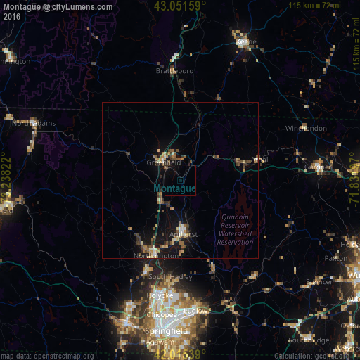
Analysis of Montague night lights 2016
Square area 10x10 km:
 0%
0%90-99
0%80-89
0%70-79
0%60-69
0%50-59
0.48%40-49
0.79%30-39
0.32%20-29
0.95%10-19
2.06%0-9
95.4%Square area 50x50 km:
0.24%90-99
0.42%80-89
0.53%70-79
0.48%60-69
0.62%50-59
0.7%40-49
0.92%30-39
0.67%20-29
0.7%10-19
3.83%0-9
90.88%Clear (daylight) street map image can be seen on geolist.org.
Map coordinates:
43° 3' 5.7" North, 73° 14' 17.6" West
42° 32' 8.3" North, 72° 32' 6.3" West
42° 0' 55.4" North, 71° 49' 55.1" West
Some cities around Montague sort by population:
• Amherst
18.8 km =11.7 mi,  175°
175°
• Northampton
25 km =15.5 mi,  200°
200°
• Greenfield
7.8 km =4.8 mi,  317°
317°
• Amherst Center
17.9 km =11.1 mi, 175°
• South Hadley
31 km =19.3 mi,  185°
185°
• Easthampton
31.9 km =19.8 mi, 200°
• Athol
26.1 km =16.2 mi,  75°
75°
• North Amherst
13.9 km =8.6 mi, 178°
4944413 (p: 8,637)
Sources (retrieved 2019-11-25):
» Earth at Night: Flat Maps 2012, 2016