Alton North (historical) night lights from space
Night Light of Alton North (historical) (Texas) from space (United States) Src. Average luminocity for 10x10km area is 72.0099% and for 50x50km: 38.3057%.
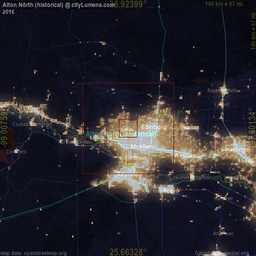
Analysis of Alton North (historical) night lights 2016
Square area 10x10 km:
 4.37%
4.37%90-99
9.72%80-89
16.47%70-79
24.01%60-69
24.6%50-59
16.67%40-49
0.99%30-39
3.17%20-29
0%10-19
0%0-9
0%Square area 50x50 km:
7.79%90-99
6.09%80-89
6.37%70-79
7.25%60-69
8.1%50-59
6.38%40-49
3.23%30-39
2.89%20-29
4.24%10-19
7.76%0-9
39.92%Clear (daylight) street map image can be seen on geolist.org.
Map coordinates:
26° 55' 26.4" North, 99° 0' 27.3" West
26° 17' 43.3" North, 98° 18' 16.1" West
25° 39' 47.8" North, 97° 36' 4.8" West
Some cities around Alton North (historical) sort by population:
• McAllen
12.6 km =7.8 mi,  144°
144°
• Edinburg
14.1 km =8.8 mi,  87°
87°
• Mission
9.1 km =5.7 mi,  193°
193°
• La Homa
7.8 km =4.8 mi,  229°
229°
• Palmview
9.6 km =6 mi,  223°
223°
• Palmview South
11.5 km =7.1 mi, 219°
• Perezville
12.4 km =7.7 mi, 230°
• Doffing
8.4 km =5.2 mi,  254°
254°
4670562 (p: 5,541)
Sources (retrieved 2019-11-25):
» Earth at Night: Flat Maps 2012, 2016