Perezville night lights from space
Night Light of Perezville (Texas) from space (United States) Src. Average luminocity for 10x10km area is 60.0317% and for 50x50km: 38.2561%.
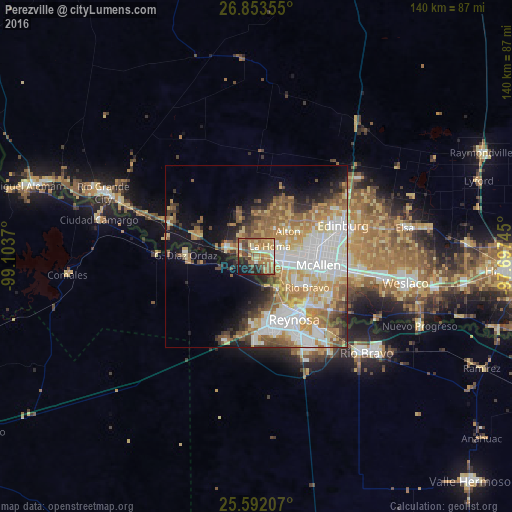
Analysis of Perezville night lights 2016
Square area 10x10 km:
 5.16%
5.16%90-99
5.75%80-89
13.69%70-79
15.87%60-69
15.87%50-59
11.71%40-49
8.93%30-39
4.96%20-29
9.33%10-19
8.33%0-9
0.4%Square area 50x50 km:
9.38%90-99
6.86%80-89
5.47%70-79
6.45%60-69
6.12%50-59
6.08%40-49
3.48%30-39
3.16%20-29
4.12%10-19
8.37%0-9
40.51%Clear (daylight) street map image can be seen on geolist.org.
Map coordinates:
26° 51' 12.8" North, 99° 6' 13.3" West
26° 13' 28.3" North, 98° 24' 2.1" West
25° 35' 31.5" North, 97° 41' 50.8" West
Some cities around Perezville sort by population:
• McAllen
17.2 km =10.7 mi,  97°
97°
• Mission
7.6 km =4.7 mi, 97°
• Alton
11.2 km =7 mi,  51°
51°
• La Homa
4.7 km =2.9 mi, 52°
• Palmview
3.1 km =1.9 mi,  71°
71°
• Palmview South
2.4 km =1.5 mi,  114°
114°
• Alton North (historical)
12.4 km =7.7 mi, 50°
• Doffing
5.8 km =3.6 mi,  14°
14°
4718491 (p: 5,376)
Sources (retrieved 2019-11-25):
» Earth at Night: Flat Maps 2012, 2016