Airmont night lights from space
Night Light of Airmont (New York) from space (United States) Src. Average luminocity for 10x10km area is 72.6916% and for 50x50km: 46.7575%.
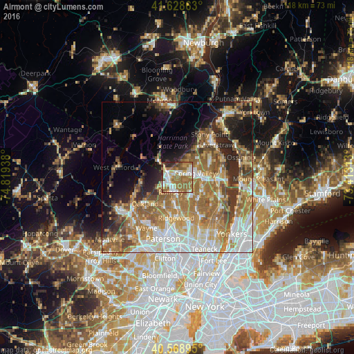
Analysis of Airmont night lights 2016
Square area 10x10 km:
 15.58%
90-99
15.26%80-89
7.79%70-79
9.25%60-69
29.38%50-59
11.36%40-49
4.71%30-39
2.11%20-29
4.55%10-19
0%0-9
0%Square area 50x50 km:
9.2%90-99
8.47%80-89
5.52%70-79
7.73%60-69
11.9%50-59
7.45%40-49
4.71%30-39
4.51%20-29
6.93%10-19
8.4%0-9
25.18%Clear (daylight) street map image can be seen on geolist.org.
Map coordinates:
41° 37' 43.1" North, 74° 49' 9.8" West
41° 6' 3.3" North, 74° 6' 58.5" West
40° 34' 8.2" North, 73° 24' 47.3" West
Some cities around Airmont sort by population:
• Mahwah
2.7 km =1.7 mi,  239°
239°
• Monsey
4.2 km =2.6 mi,  74°
74°
• Ramsey
5.3 km =3.3 mi,  203°
203°
• Suffern
3.2 km =2 mi,  298°
298°
• Upper Saddle River
5 km =3.1 mi,  162°
162°
• Chestnut Ridge
5.4 km =3.4 mi,  110°
110°
• Viola
4.9 km =3 mi,  35°
35°
• Kaser
4.7 km =2.9 mi,  61°
61°
5106817 (p: 8,891)
Sources (retrieved 2019-11-25):
» Earth at Night: Flat Maps 2012, 2016