Bweyogerere night lights from space
Night Light of Bweyogerere (Central Region) from space (Uganda) Src. Average luminocity for 10x10km area is 52.7749% and for 50x50km: 13.1647%.
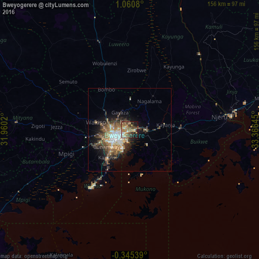
Analysis of Bweyogerere night lights 2016
Square area 10x10 km:
 3.68%
3.68%90-99
6.93%80-89
5.84%70-79
11.04%60-69
12.55%50-59
13.2%40-49
16.45%30-39
7.14%20-29
7.79%10-19
15.15%0-9
0.22%Square area 50x50 km:
1.5%90-99
1.94%80-89
1.17%70-79
1.75%60-69
2.69%50-59
2.35%40-49
2.86%30-39
2.69%20-29
3.03%10-19
6.52%0-9
73.51%Clear (daylight) street map image can be seen on geolist.org.
Map coordinates:
1° 3' 38.9" North, 31° 57' 36.7" East
0° 21' 27.8" North, 32° 39' 48" East
0° 20' 43.4" South, 33° 21' 59.2" East
Some cities around Bweyogerere sort by population:
• Kampala
10.1 km =6.3 mi,  242°
242°
• Mukono
10.2 km =6.3 mi,  92°
92°
• Entebbe
39.3 km =24.4 mi,  211°
211°
• Lugazi
30.5 km =19 mi, 87°
• Wakiso
23.3 km =14.5 mi,  282°
282°
• Kireka
1.9 km =1.2 mi,  234°
234°
• Mpigi
41.6 km =25.8 mi,  249°
249°
• Kajansi
21.3 km =13.2 mi,  222°
222°
233738 (p: 11,473)
Sources (retrieved 2019-11-25):
» Earth at Night: Flat Maps 2012, 2016