Peresichna night lights from space
Night Light of Peresichna (Kharkiv) from space (Ukraine) Src. Average luminocity for 10x10km area is 0.2493% and for 50x50km: 6.7295%.
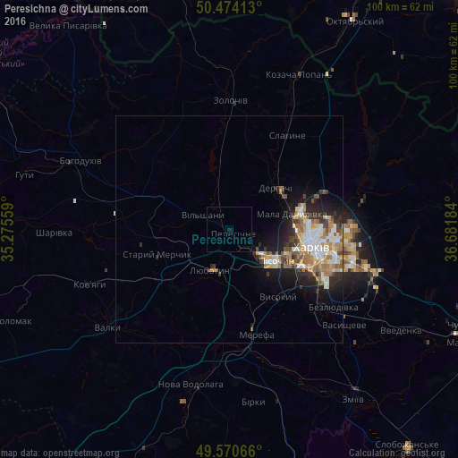
Analysis of Peresichna night lights 2016
Square area 10x10 km:
 0%
0%90-99
0%80-89
0%70-79
0%60-69
0%50-59
0%40-49
0%30-39
0%20-29
0%10-19
1.12%0-9
98.88%Square area 50x50 km:
1.06%90-99
1.3%80-89
0.72%70-79
0.89%60-69
1.27%50-59
0.84%40-49
0.75%30-39
0.81%20-29
1.77%10-19
3.66%0-9
86.92%Clear (daylight) street map image can be seen on geolist.org.
Map coordinates:
50° 28' 26.9" North, 35° 16' 32.1" East
50° 1' 28.3" North, 35° 58' 43.4" East
49° 34' 14.4" North, 36° 40' 54.6" East
Some cities around Peresichna sort by population:
• Lyubotyn
9.3 km =5.8 mi,  202°
202°
• Derhachi
13.7 km =8.5 mi,  48°
48°
• Solonytsivka
5 km =3.1 mi,  127°
127°
• Vysokyy
18 km =11.2 mi,  145°
145°
• Pokotylivka
18.7 km =11.6 mi, 131°
• Pivdenne
17 km =10.6 mi,  157°
157°
• Mala Danylivka
14 km =8.7 mi,  71°
71°
• Budy
15.1 km =9.4 mi,  168°
168°
697676 (p: 6,894)
Sources (retrieved 2019-11-25):
» Earth at Night: Flat Maps 2012, 2016