Vorzel’ night lights from space
Night Light of Vorzel’ (Kyiv) from space (Ukraine) Src. Average luminocity for 10x10km area is 19.2112% and for 50x50km: 14.838%.
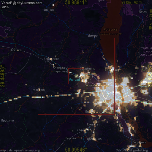
Analysis of Vorzel’ night lights 2016
Square area 10x10 km:
 2.14%
2.14%90-99
3.21%80-89
2.67%70-79
3.21%60-69
3.74%50-59
0.53%40-49
2.67%30-39
0.67%20-29
4.95%10-19
19.79%0-9
56.42%Square area 50x50 km:
3.71%90-99
3.07%80-89
1.22%70-79
1.69%60-69
1.58%50-59
1.81%40-49
1.84%30-39
1.77%20-29
3.47%10-19
7.49%0-9
72.34%Clear (daylight) street map image can be seen on geolist.org.
Map coordinates:
50° 59' 20.8" North, 29° 26' 59.7" East
50° 32' 39.8" North, 30° 9' 11" East
50° 5' 43.7" North, 30° 51' 22.2" East
Some cities around Vorzel’ sort by population:
• Bucha
4.2 km =2.6 mi,  91°
91°
• Irpin
7.3 km =4.5 mi,  110°
110°
• Kotsyubyns’ke
13.9 km =8.6 mi,  116°
116°
• Hostomel
8.4 km =5.2 mi,  71°
71°
• Borodianka
19.9 km =12.4 mi,  304°
304°
• Novi Petrivtsi
22.5 km =14 mi, 65°
• Sofiyivska Borschagivka
21.3 km =13.2 mi,  134°
134°
• Horenka
12.7 km =7.9 mi,  83°
83°
688956 (p: 8,500)
Sources (retrieved 2019-11-25):
» Earth at Night: Flat Maps 2012, 2016