Mirnoye night lights from space
Night Light of Mirnoye (Crimea) from space (Ukraine) Src. Average luminocity for 10x10km area is 38.9079% and for 50x50km: 3.6971%.
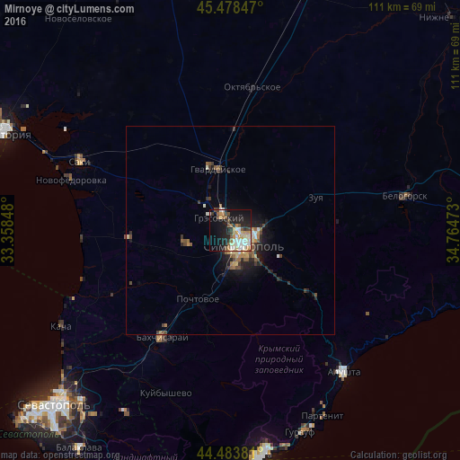
Analysis of Mirnoye night lights 2016
Square area 10x10 km:
 6.35%
6.35%90-99
9.52%80-89
3.02%70-79
6.19%60-69
4.92%50-59
3.81%40-49
4.13%30-39
3.81%20-29
11.75%10-19
27.62%0-9
18.89%Square area 50x50 km:
0.33%90-99
0.56%80-89
0.36%70-79
0.48%60-69
0.53%50-59
0.63%40-49
0.6%30-39
0.49%20-29
1.17%10-19
2.71%0-9
92.13%Clear (daylight) street map image can be seen on geolist.org.
Map coordinates:
45° 28' 42.5" North, 33° 21' 30.5" East
44° 58' 59.9" North, 34° 3' 41.8" East
44° 29' 1.7" North, 34° 45' 53" East
Some cities around Mirnoye sort by population:
• Simferopol
4.8 km =3 mi,  126°
126°
• Bakhchysarai
30 km =18.6 mi,  212°
212°
• Hvardiiske
15.2 km =9.4 mi,  348°
348°
• Gresovskiy
3.9 km =2.4 mi,  314°
314°
• Molodyozhnoye
2.3 km =1.4 mi, 349°
• Zuya
21.9 km =13.6 mi,  68°
68°
• Pionerskoye
15.9 km =9.9 mi,  135°
135°
• Chisten’koye
11.4 km =7.1 mi,  185°
185°
707240 (p: 9,284)
Sources (retrieved 2019-11-25):
» Earth at Night: Flat Maps 2012, 2016