Chisten’koye night lights from space
Night Light of Chisten’koye (Crimea) from space (Ukraine) Src. Average luminocity for 10x10km area is 9.7508% and for 50x50km: 3.7455%.
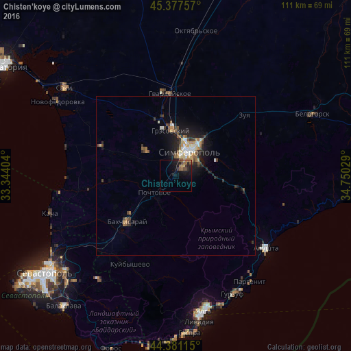
Analysis of Chisten’koye night lights 2016
Square area 10x10 km:
 0%
0%90-99
0%80-89
0.95%70-79
1.11%60-69
2.54%50-59
2.38%40-49
2.06%30-39
1.11%20-29
3.49%10-19
13.17%0-9
73.17%Square area 50x50 km:
0.34%90-99
0.55%80-89
0.37%70-79
0.49%60-69
0.57%50-59
0.63%40-49
0.61%30-39
0.49%20-29
1.17%10-19
2.74%0-9
92.06%Clear (daylight) street map image can be seen on geolist.org.
Map coordinates:
45° 22' 39.3" North, 33° 20' 38.5" East
44° 52' 53.5" North, 34° 2' 49.8" East
44° 22' 52.1" North, 34° 45' 1" East
Some cities around Chisten’koye sort by population:
• Simferopol
9.8 km =6.1 mi,  30°
30°
• Bakhchysarai
20.5 km =12.7 mi,  226°
226°
• Hvardiiske
26.2 km =16.3 mi,  355°
355°
• Gresovskiy
14.2 km =8.8 mi,  353°
353°
• Mirnoye
11.4 km =7.1 mi,  5°
5°
• Molodyozhnoye
13.6 km =8.5 mi,  3°
3°
• Zuya
28.9 km =18 mi,  48°
48°
• Pionerskoye
12.2 km =7.6 mi,  90°
90°
710454 (p: 5,126)
Sources (retrieved 2019-11-25):
» Earth at Night: Flat Maps 2012, 2016