Mezhova night lights from space
Night Light of Mezhova (Dnipropetrovsk) from space (Ukraine) Src. Average luminocity for 10x10km area is 0.1964% and for 50x50km: 0.3196%.
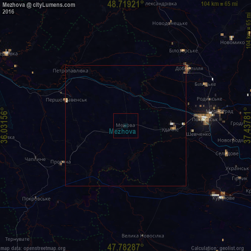
Analysis of Mezhova night lights 2016
Square area 10x10 km:
 0%
0%90-99
0%80-89
0%70-79
0%60-69
0%50-59
0%40-49
0%30-39
0%20-29
0%10-19
1.19%0-9
98.81%Square area 50x50 km:
0.05%90-99
0.05%80-89
0.03%70-79
0.03%60-69
0.07%50-59
0.05%40-49
0.06%30-39
0.05%20-29
0.04%10-19
0.07%0-9
99.52%Clear (daylight) street map image can be seen on geolist.org.
Map coordinates:
48° 43' 9.2" North, 36° 1' 53.6" East
48° 15' 11.4" North, 36° 44' 4.8" East
47° 46' 58.3" North, 37° 26' 16.1" East
Some cities around Mezhova sort by population:
• Pokrovsk
32.8 km =20.4 mi,  84°
84°
• Myrnohrad
39.4 km =24.5 mi, 81°
• Dobropillya
34.7 km =21.6 mi,  48°
48°
• Selydove
43.5 km =27 mi,  105°
105°
• Rodyns’ke
36.6 km =22.7 mi,  72°
72°
• Bilyts’ke
37.1 km =23.1 mi,  62°
62°
• Petropavlivka
31.6 km =19.6 mi,  315°
315°
• Novodonets’ke
46.3 km =28.8 mi,  23°
23°
701305 (p: 7,817)
Sources (retrieved 2019-11-25):
» Earth at Night: Flat Maps 2012, 2016