Manhush night lights from space
Night Light of Manhush (Donetsk) from space (Ukraine) Src. Average luminocity for 10x10km area is 0.6648% and for 50x50km: 5.3833%.
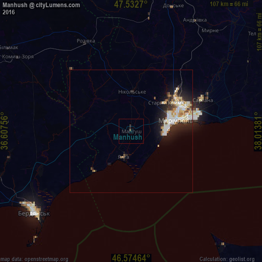
Analysis of Manhush night lights 2016
Square area 10x10 km:
 0%
0%90-99
0%80-89
0%70-79
0%60-69
0%50-59
0.57%40-49
0%30-39
0.57%20-29
0.57%10-19
0%0-9
98.3%Square area 50x50 km:
0.84%90-99
1.39%80-89
0.71%70-79
0.59%60-69
0.56%50-59
0.46%40-49
0.42%30-39
0.75%20-29
1.97%10-19
2.82%0-9
89.5%Clear (daylight) street map image can be seen on geolist.org.
Map coordinates:
47° 31' 57.7" North, 36° 36' 27.2" East
47° 3' 21" North, 37° 18' 38.4" East
46° 34' 28.7" North, 38° 0' 49.7" East
Some cities around Manhush sort by population:
• Mariupol
18 km =11.2 mi,  75°
75°
• Berdyansk
50.5 km =31.4 mi,  230°
230°
• Novoazovs'k
59.1 km =36.7 mi, 83°
• Sartana
31.8 km =19.8 mi,  65°
65°
• Kuybysheve
60.2 km =37.4 mi,  303°
303°
• Dolzhanskaya, RU
60 km =37.3 mi,  141°
141°
• Staryy Krym
17.9 km =11.1 mi,  49°
49°
• Yalta
10.7 km =6.6 mi,  195°
195°
697613 (p: 8,153)
Sources (retrieved 2019-11-25):
» Earth at Night: Flat Maps 2012, 2016