Dymer night lights from space
Night Light of Dymer (Kyiv) from space (Ukraine) Src. Average luminocity for 10x10km area is 0.1975% and for 50x50km: 1.3927%.
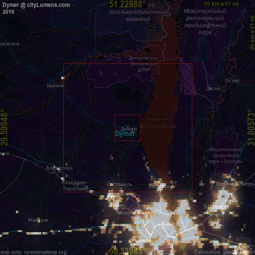
Analysis of Dymer night lights 2016
Square area 10x10 km:
 0%
0%90-99
0%80-89
0%70-79
0%60-69
0%50-59
0%40-49
0%30-39
0.56%20-29
0%10-19
0%0-9
99.44%Square area 50x50 km:
0.13%90-99
0.16%80-89
0.04%70-79
0.14%60-69
0.1%50-59
0.15%40-49
0.24%30-39
0.36%20-29
0.47%10-19
1.65%0-9
96.57%Clear (daylight) street map image can be seen on geolist.org.
Map coordinates:
51° 13' 44" North, 29° 35' 58.1" East
50° 47' 11.3" North, 30° 18' 9.4" East
50° 20' 23.4" North, 31° 0' 20.6" East
Some cities around Dymer sort by population:
• Bucha
27.8 km =17.3 mi,  193°
193°
• Irpin
29.7 km =18.5 mi, 187°
• Vyshhorod
26 km =16.2 mi,  149°
149°
• Hostomel
24.4 km =15.2 mi, 186°
• Borodianka
31.2 km =19.4 mi,  239°
239°
• Vorzel’
28.9 km =18 mi,  201°
201°
• Novi Petrivtsi
20.3 km =12.6 mi, 150°
• Horenka
25.6 km =15.9 mi,  175°
175°
709373 (p: 5,653)
Sources (retrieved 2019-11-25):
» Earth at Night: Flat Maps 2012, 2016