Rio Claro night lights from space
Night Light of Rio Claro (Mayaro) from space (Trinidad and Tobago) Src. Average luminocity for 10x10km area is 31.2624% and for 50x50km: 20.8698%.
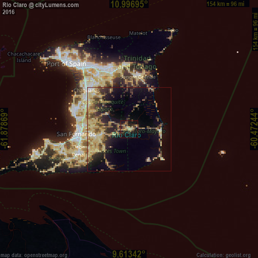

Analysis of Rio Claro night lights 2016
Square area 10x10 km:
 0%
0%90-99
0.41%80-89
10.12%70-79
5.58%60-69
3.72%50-59
4.75%40-49
5.99%30-39
8.68%20-29
3.1%10-19
39.05%0-9
18.6%Square area 50x50 km:
0.6%90-99
1.81%80-89
6.93%70-79
3.05%60-69
2.87%50-59
3.01%40-49
3.66%30-39
3.96%20-29
4.89%10-19
9.38%0-9
59.85%Clear (daylight) street map image can be seen on geolist.org.
Map coordinates:
10° 59' 49" North, 61° 52' 43.3" West
10° 18' 21.4" North, 61° 10' 32" West
9° 36' 48.3" North, 60° 28' 20.8" West
Some cities around Rio Claro sort by population:
• Chaguanas
35.3 km =21.9 mi,  311°
311°
• Mon Repos
29.7 km =18.5 mi,  264°
264°
• San Fernando
32.2 km =20 mi, 264°
• Marabella
29.7 km =18.5 mi,  270°
270°
• Sangre Grande
31.6 km =19.6 mi,  9°
9°
• Peñal
35.4 km =22 mi,  244°
244°
• Princes Town
21.7 km =13.5 mi, 259°
• Couva
34.5 km =21.4 mi,  292°
292°
3573840 (p: 35,650)
Sources (retrieved 2019-11-25):
» Earth at Night: Flat Maps 2012, 2016