Princes Town night lights from space
Night Light of Princes Town from space (Trinidad and Tobago) Src. Average luminocity for 10x10km area is 79.8202% and for 50x50km: 35.5782%.
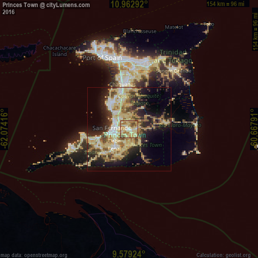
Analysis of Princes Town night lights 2016
Square area 10x10 km:
 4.96%
4.96%90-99
13.43%80-89
45.87%70-79
11.36%60-69
13.22%50-59
7.02%40-49
4.13%30-39
0%20-29
0%10-19
0%0-9
0%Square area 50x50 km:
2.97%90-99
5.78%80-89
12.7%70-79
4.18%60-69
4.4%50-59
4.35%40-49
4.57%30-39
4.65%20-29
7.47%10-19
11.77%0-9
37.14%Clear (daylight) street map image can be seen on geolist.org.
Map coordinates:
10° 57' 46.5" North, 62° 4' 27" West
10° 16' 18.6" North, 61° 22' 15.7" West
9° 34' 45.3" North, 60° 40' 4.5" West
Some cities around Princes Town sort by population:
• Chaguanas
27.7 km =17.2 mi,  349°
349°
• Mon Repos
8.2 km =5.1 mi,  276°
276°
• San Fernando
10.7 km =6.6 mi,  274°
274°
• Rio Claro
21.7 km =13.5 mi,  79°
79°
• Marabella
9.1 km =5.7 mi,  294°
294°
• Peñal
15.7 km =9.8 mi,  221°
221°
• Siparia
20.5 km =12.7 mi,  226°
226°
• Couva
19.8 km =12.3 mi,  327°
327°
3573882 (p: 10,000)
Sources (retrieved 2019-11-25):
» Earth at Night: Flat Maps 2012, 2016