Yeşilhisar night lights from space
Night Light of Yeşilhisar (Kayseri) from space (Turkey) Src. Average luminocity for 10x10km area is 7.5629% and for 50x50km: 2.3869%.
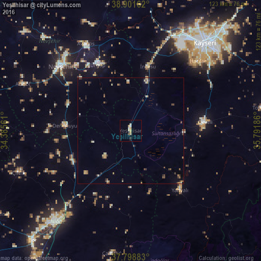
Analysis of Yeşilhisar night lights 2016
Square area 10x10 km:
 0.17%
0.17%90-99
1.7%80-89
2.38%70-79
1.7%60-69
0.17%50-59
0.51%40-49
0.17%30-39
0.51%20-29
1.53%10-19
0%0-9
91.16%Square area 50x50 km:
0.01%90-99
0.4%80-89
0.37%70-79
0.45%60-69
0.33%50-59
0.25%40-49
0.48%30-39
0.35%20-29
0.49%10-19
0.27%0-9
96.61%Clear (daylight) street map image can be seen on geolist.org.
Map coordinates:
38° 54' 5.8" North, 34° 23' 8.2" East
38° 21' 8.4" North, 35° 5' 19.4" East
37° 47' 55.8" North, 35° 47' 30.7" East
Some cities around Yeşilhisar sort by population:
• Nevşehir
44.6 km =27.7 mi,  312°
312°
• Develi
35.4 km =22 mi,  83°
83°
• Yahyalı
36.4 km =22.6 mi,  139°
139°
• Hacılar
45.3 km =28.1 mi,  43°
43°
• Ürgüp
34.5 km =21.4 mi,  333°
333°
• Avanos
45.5 km =28.3 mi, 332°
• Derinkuyu
31 km =19.3 mi,  274°
274°
• Göreme
39.2 km =24.4 mi, 325°
296860 (p: 14,354)
Sources (retrieved 2019-11-25):
» Earth at Night: Flat Maps 2012, 2016