Uludere night lights from space
Night Light of Uludere (Şırnak) from space (Turkey) Src. Average luminocity for 10x10km area is 10.2776% and for 50x50km: 2.0336%.
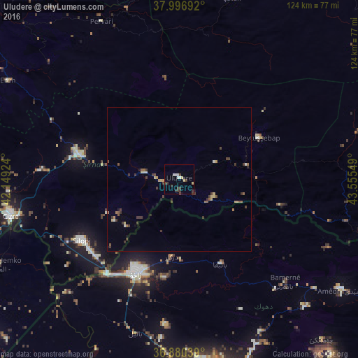
Analysis of Uludere night lights 2016
Square area 10x10 km:
 0%
0%90-99
3.25%80-89
1.95%70-79
0%60-69
0%50-59
0%40-49
2.27%30-39
5.52%20-29
0%10-19
0.65%0-9
86.36%Square area 50x50 km:
0.01%90-99
0.29%80-89
0.33%70-79
0.18%60-69
0.21%50-59
0.25%40-49
0.47%30-39
0.93%20-29
0.11%10-19
0.27%0-9
96.95%Clear (daylight) street map image can be seen on geolist.org.
Map coordinates:
37° 59' 48.9" North, 42° 8' 57.3" East
37° 26' 26.7" North, 42° 51' 8.5" East
36° 52' 49.4" North, 43° 33' 19.8" East
Some cities around Uludere sort by population:
• Zaxo, IQ
35.7 km =22.2 mi,  204°
204°
• Cizre
60.2 km =37.4 mi,  258°
258°
• Silopi
40.8 km =25.4 mi,  237°
237°
• Şırnak
36.1 km =22.4 mi,  283°
283°
• Batifa, IQ
32.8 km =20.4 mi,  154°
154°
• Beytüşşebap
30.8 km =19.1 mi,  63°
63°
• Pervari
61.2 km =38 mi,  334°
334°
• Kumçatı
49.9 km =31 mi,  273°
273°
298433 (p: 8,827)
Sources (retrieved 2019-11-25):
» Earth at Night: Flat Maps 2012, 2016