Solhan night lights from space
Night Light of Solhan (Bingöl) from space (Turkey) Src. Average luminocity for 10x10km area is 7.1331% and for 50x50km: 0.7991%.
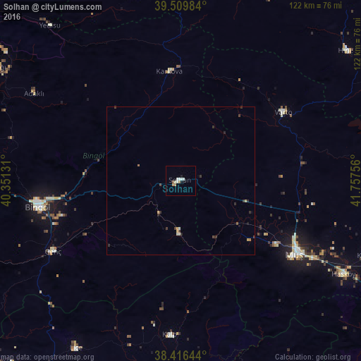
Analysis of Solhan night lights 2016
Square area 10x10 km:
100  0.81%
0.81%
90-99 2.92%
80-89 0.16%
70-79 1.3%
60-69 0.65%
50-59 0.65%
40-49 0%
30-39 0%
20-29 0.16%
10-19 0.97%
0-9 92.37%
0.81%90-99
2.92%80-89
0.16%70-79
1.3%60-69
0.65%50-59
0.65%40-49
0%30-39
0%20-29
0.16%10-19
0.97%0-9
92.37%Square area 50x50 km:
100 0.03%
90-99 0.2%
80-89 0.07%
70-79 0.13%
60-69 0.08%
50-59 0.05%
40-49 0.15%
30-39 0.24%
20-29 0.18%
10-19 0.09%
0-9 98.79%
0.03%90-99
0.2%80-89
0.07%70-79
0.13%60-69
0.08%50-59
0.05%40-49
0.15%30-39
0.24%20-29
0.18%10-19
0.09%0-9
98.79%Clear (daylight) street map image can be seen on geolist.org.
Map coordinates:
39° 30' 35.4" North, 40° 21' 4.7" East
38° 57' 54.9" North, 41° 3' 15.9" East
38° 24' 59.2" North, 41° 45' 27.2" East
Some cities around Solhan sort by population:
• Muş
45.4 km =28.2 mi,  124°
124°
• Bingöl
49.3 km =30.6 mi,  259°
259°
• Kulp
52.2 km =32.4 mi,  184°
184°
• Genç
49.7 km =30.9 mi,  240°
240°
• Varto
41.6 km =25.8 mi,  56°
56°
• Lice
66.9 km =41.6 mi,  212°
212°
• Karlıova
36.4 km =22.6 mi,  353°
353°
• Korkut
68.2 km =42.4 mi,  112°
112°
300377 (p: 15,303)
Sources (retrieved 2019-11-25):
» Earth at Night: Flat Maps 2012, 2016