Avsallar night lights from space
Night Light of Avsallar (Antalya) from space (Turkey) Src. Average luminocity for 10x10km area is 41.5549% and for 50x50km: 10.9591%.
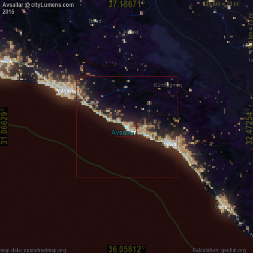
Analysis of Avsallar night lights 2016
Square area 10x10 km:
 4.03%
4.03%90-99
12.09%80-89
4.03%70-79
9.71%60-69
3.85%50-59
2.38%40-49
1.83%30-39
3.66%20-29
14.1%10-19
37.55%0-9
6.78%Square area 50x50 km:
0.62%90-99
1.98%80-89
1.33%70-79
1.79%60-69
0.94%50-59
1.03%40-49
1.83%30-39
2.36%20-29
3.76%10-19
11.03%0-9
73.33%Clear (daylight) street map image can be seen on geolist.org.
Map coordinates:
37° 11' 12.2" North, 31° 3' 58.6" East
36° 37' 28.1" North, 31° 46' 9.9" East
36° 3' 29.2" North, 32° 28' 21.1" East
Some cities around Avsallar sort by population:
• Alanya
22.4 km =13.9 mi,  113°
113°
• Manavgat
34.2 km =21.3 mi,  301°
301°
• Mahmutlar
32.1 km =19.9 mi,  116°
116°
• Akseki
47.2 km =29.3 mi,  2°
2°
• Side
37.4 km =23.2 mi,  294°
294°
• Türkler
5.2 km =3.2 mi, 118°
• Eksere
29.4 km =18.3 mi,  44°
44°
• Payallar
7.7 km =4.8 mi, 109°
322887 (p: 12,829)
Sources (retrieved 2019-11-25):
» Earth at Night: Flat Maps 2012, 2016