Serinyol night lights from space
Night Light of Serinyol (Hatay) from space (Turkey) Src. Average luminocity for 10x10km area is 40.9983% and for 50x50km: 22.2863%.
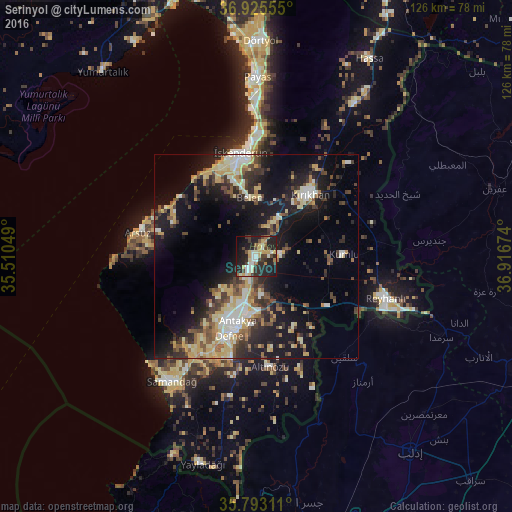
Analysis of Serinyol night lights 2016
Square area 10x10 km:
 2.97%
2.97%90-99
9.79%80-89
4.9%70-79
7.52%60-69
3.32%50-59
2.97%40-49
7.34%30-39
6.29%20-29
22.55%10-19
27.45%0-9
4.9%Square area 50x50 km:
1.65%90-99
3.95%80-89
4.04%70-79
3.31%60-69
1.87%50-59
2.68%40-49
4.12%30-39
3.75%20-29
6.15%10-19
17.31%0-9
51.18%Clear (daylight) street map image can be seen on geolist.org.
Map coordinates:
36° 55' 32" North, 35° 30' 37.8" East
36° 21' 41" North, 36° 12' 49" East
35° 47' 35.2" North, 36° 55' 0.3" East
Some cities around Serinyol sort by population:
• Antakya
17.9 km =11.1 mi,  196°
196°
• İskenderun
25.4 km =15.8 mi,  351°
351°
• Kırıkhan
20 km =12.4 mi,  40°
40°
• Salqīn, SY
32.7 km =20.3 mi,  139°
139°
• Belen
14.2 km =8.8 mi, 353°
• Denizciler
31.1 km =19.3 mi,  0°
0°
• Kastal
12.9 km =8 mi,  169°
169°
• Dursunlu
22.1 km =13.7 mi,  193°
193°
301089 (p: 16,753)
Sources (retrieved 2019-11-25):
» Earth at Night: Flat Maps 2012, 2016