Dursunlu night lights from space
Night Light of Dursunlu (Hatay) from space (Turkey) Src. Average luminocity for 10x10km area is 64.6783% and for 50x50km: 20.0827%.
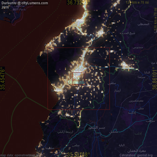
Analysis of Dursunlu night lights 2016
Square area 10x10 km:
 10.31%
90-99
16.08%80-89
13.81%70-79
12.06%60-69
6.82%50-59
7.34%40-49
6.82%30-39
6.82%20-29
13.81%10-19
6.12%0-9
0%Square area 50x50 km:
1.25%90-99
3.29%80-89
3.89%70-79
2.99%60-69
1.81%50-59
2.97%40-49
3.73%30-39
3.68%20-29
5.67%10-19
13.16%0-9
57.56%Clear (daylight) street map image can be seen on geolist.org.
Map coordinates:
36° 43' 58.5" North, 35° 27' 17.1" East
36° 10' 2.5" North, 36° 9' 28.4" East
35° 35' 51.6" North, 36° 51' 39.6" East
Some cities around Dursunlu sort by population:
• Antakya
4.4 km =2.7 mi,  359°
359°
• Reyhanlı
38.4 km =23.9 mi,  73°
73°
• Salqīn, SY
26.6 km =16.5 mi,  96°
96°
• Kafr Takhārīm, SY
32.6 km =20.3 mi, 99°
• Belen
35.9 km =22.3 mi,  5°
5°
• Serinyol
22.1 km =13.7 mi, 13°
• Yayladağı
30.7 km =19.1 mi,  196°
196°
• Kastal
11.6 km =7.2 mi,  39°
39°
438119 (p: 5,147)
Sources (retrieved 2019-11-25):
» Earth at Night: Flat Maps 2012, 2016