Sarıgöl night lights from space
Night Light of Sarıgöl (Manisa) from space (Turkey) Src. Average luminocity for 10x10km area is 20.7551% and for 50x50km: 7.982%.
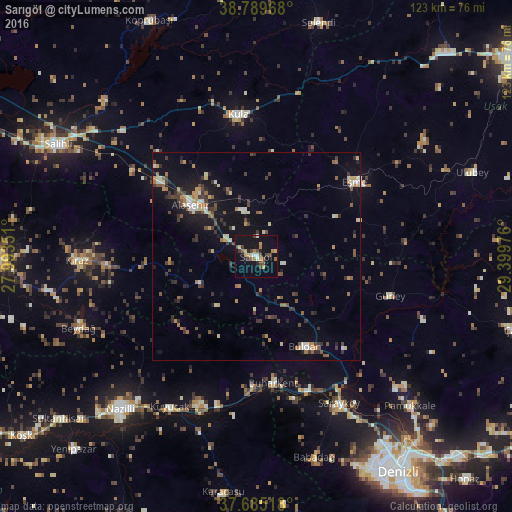
Analysis of Sarıgöl night lights 2016
Square area 10x10 km:
 1.02%
1.02%90-99
2.04%80-89
1.87%70-79
3.74%60-69
2.89%50-59
3.06%40-49
4.08%30-39
3.23%20-29
3.06%10-19
23.81%0-9
51.19%Square area 50x50 km:
0.34%90-99
1.04%80-89
0.86%70-79
0.94%60-69
1.04%50-59
1.09%40-49
1.44%30-39
2.13%20-29
1.44%10-19
6.33%0-9
83.35%Clear (daylight) street map image can be seen on geolist.org.
Map coordinates:
38° 47' 22.8" North, 27° 59' 36.6" East
38° 14' 22.3" North, 28° 41' 47.9" East
37° 41' 6.6" North, 29° 23' 59.1" East
Some cities around Sarıgöl sort by population:
• Alaşehir
20 km =12.4 mi,  308°
308°
• Kula
34.5 km =21.4 mi,  353°
353°
• Sarayköy
40.3 km =25 mi,  150°
150°
• Buldan
24.6 km =15.3 mi, 151°
• Kiraz
43 km =26.7 mi,  268°
268°
• Eşme
29.7 km =18.5 mi,  53°
53°
• Buharkent
30.9 km =19.2 mi,  172°
172°
• Kuyucak
41.8 km =26 mi,  209°
209°
301731 (p: 12,794)
Sources (retrieved 2019-11-25):
» Earth at Night: Flat Maps 2012, 2016