Buharkent night lights from space
Night Light of Buharkent (Aydın) from space (Turkey) Src. Average luminocity for 10x10km area is 15.9237% and for 50x50km: 9.0868%.
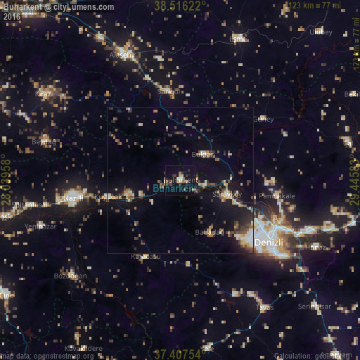
Analysis of Buharkent night lights 2016
Square area 10x10 km:
 0.32%
0.32%90-99
2.6%80-89
2.76%70-79
0.32%60-69
2.44%50-59
0.97%40-49
2.11%30-39
3.9%20-29
4.71%10-19
5.03%0-9
74.84%Square area 50x50 km:
0.42%90-99
1.27%80-89
1.05%70-79
0.89%60-69
1.18%50-59
1.34%40-49
1.7%30-39
2.13%20-29
1.96%10-19
5.78%0-9
82.31%Clear (daylight) street map image can be seen on geolist.org.
Map coordinates:
38° 30' 58.4" North, 28° 2' 22.5" East
37° 57' 50.3" North, 28° 44' 33.7" East
37° 24' 27.1" North, 29° 26' 45" East
Some cities around Buharkent sort by population:
• Denizli
36.9 km =22.9 mi,  124°
124°
• Merkezefendi
31.7 km =19.7 mi, 123°
• Sarayköy
16.6 km =10.3 mi,  105°
105°
• Buldan
11.9 km =7.4 mi,  40°
40°
• Sarıgöl
30.9 km =19.2 mi,  352°
352°
• Pamukkale
33.3 km =20.7 mi,  99°
99°
• Kuyucak
25.5 km =15.8 mi,  257°
257°
• Karacasu
28.8 km =17.9 mi,  204°
204°
320374 (p: 7,723)
Sources (retrieved 2019-11-25):
» Earth at Night: Flat Maps 2012, 2016