Dikili night lights from space
Night Light of Dikili (İzmir) from space (Turkey) Src. Average luminocity for 10x10km area is 25.6948% and for 50x50km: 9.0921%.
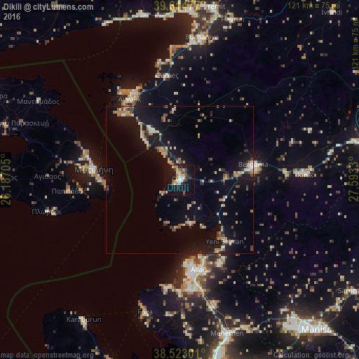
Analysis of Dikili night lights 2016
Square area 10x10 km:
 1.62%
1.62%90-99
6.01%80-89
2.92%70-79
1.3%60-69
5.36%50-59
2.11%40-49
2.92%30-39
2.92%20-29
3.25%10-19
39.77%0-9
31.82%Square area 50x50 km:
0.28%90-99
1.44%80-89
1.14%70-79
0.99%60-69
1.65%50-59
0.74%40-49
1.04%30-39
1.47%20-29
1.59%10-19
10.2%0-9
79.48%Clear (daylight) street map image can be seen on geolist.org.
Map coordinates:
39° 36' 53.2" North, 26° 11' 13.4" East
39° 4' 15.6" North, 26° 53' 24.6" East
38° 31' 22.8" North, 27° 35' 35.9" East
Some cities around Dikili sort by population:
• Ayvalık
32.4 km =20.1 mi,  328°
328°
• Bergama
25.7 km =16 mi,  77°
77°
• Menemen
53.8 km =33.4 mi,  163°
163°
• Aliağa
31 km =19.3 mi,  166°
166°
• Burhaniye
48.3 km =30 mi,  8°
8°
• Mytilene, GR
29.2 km =18.1 mi,  278°
278°
• Foça
46 km =28.6 mi,  194°
194°
• Kınık
42.6 km =26.5 mi,  87°
87°
316726 (p: 14,125)
Sources (retrieved 2019-11-25):
» Earth at Night: Flat Maps 2012, 2016