Foça night lights from space
Night Light of Foça (İzmir) from space (Turkey) Src. Average luminocity for 10x10km area is 16.9107% and for 50x50km: 12.615%.
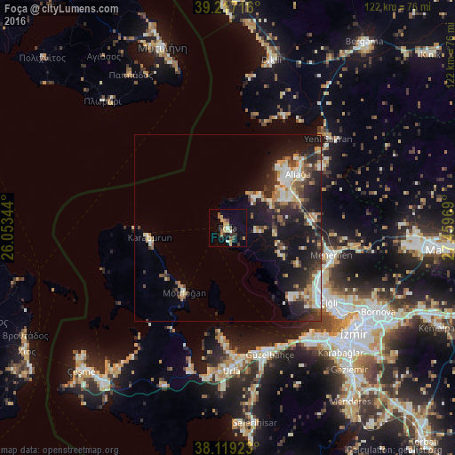
Analysis of Foça night lights 2016
Square area 10x10 km:
 0.49%
0.49%90-99
1.46%80-89
3.08%70-79
3.41%60-69
2.6%50-59
1.95%40-49
1.3%30-39
3.57%20-29
2.92%10-19
5.52%0-9
73.7%Square area 50x50 km:
1.15%90-99
2.72%80-89
1.14%70-79
1.4%60-69
1.92%50-59
1.07%40-49
2.07%30-39
2.27%20-29
4.62%10-19
9.45%0-9
72.18%Clear (daylight) street map image can be seen on geolist.org.
Map coordinates:
39° 13' 1.8" North, 26° 3' 12.4" East
38° 40' 13.1" North, 26° 45' 23.6" East
38° 7' 9.2" North, 27° 27' 34.9" East
Some cities around Foça sort by population:
• İzmir
43.9 km =27.3 mi,  130°
130°
• Karabağlar
46.6 km =29 mi,  135°
135°
• Menemen
28.1 km =17.5 mi,  104°
104°
• Urla
38.6 km =24 mi,  179°
179°
• Aliağa
23.6 km =14.7 mi,  52°
52°
• Mytilene, GR
51.7 km =32.1 mi,  340°
340°
• Seferihisar
53.1 km =33 mi,  172°
172°
• Dikili
46 km =28.6 mi,  14°
14°
314903 (p: 15,189)
Sources (retrieved 2019-11-25):
» Earth at Night: Flat Maps 2012, 2016