Baykan night lights from space
Night Light of Baykan (Siirt) from space (Turkey) Src. Average luminocity for 10x10km area is 6.7874% and for 50x50km: 3.8818%.
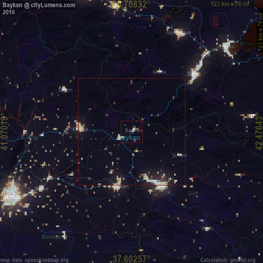
Analysis of Baykan night lights 2016
Square area 10x10 km:
100  0.51%
0.51%
90-99 1.36%
80-89 0.85%
70-79 0.68%
60-69 0%
50-59 0%
40-49 3.4%
30-39 1.36%
20-29 1.02%
10-19 0%
0-9 90.82%
0.51%90-99
1.36%80-89
0.85%70-79
0.68%60-69
0%50-59
0%40-49
3.4%30-39
1.36%20-29
1.02%10-19
0%0-9
90.82%Square area 50x50 km:
100 0.18%
90-99 0.74%
80-89 0.6%
70-79 0.32%
60-69 0.32%
50-59 0.42%
40-49 0.73%
30-39 0.77%
20-29 0.95%
10-19 2.59%
0-9 92.37%
0.18%90-99
0.74%80-89
0.6%70-79
0.32%60-69
0.32%50-59
0.42%40-49
0.73%30-39
0.77%20-29
0.95%10-19
2.59%0-9
92.37%Clear (daylight) street map image can be seen on geolist.org.
Map coordinates:
38° 42' 30" North, 41° 4' 12.6" East
38° 9' 27.1" North, 41° 46' 23.9" East
37° 36' 9.3" North, 42° 28' 35.1" East
Some cities around Baykan sort by population:
• Siirt
29.3 km =18.2 mi,  149°
149°
• Bitlis
39.8 km =24.7 mi,  47°
47°
• Kurtalan
27 km =16.8 mi,  196°
196°
• Kozluk
26.1 km =16.2 mi,  278°
278°
• Sason
36.7 km =22.8 mi,  301°
301°
• Kayabağlar
21.2 km =13.2 mi,  205°
205°
• Mutki
30.5 km =19 mi,  24°
24°
• Şirvan
24.4 km =15.2 mi,  115°
115°
321750 (p: 11,346)
Sources (retrieved 2019-11-25):
» Earth at Night: Flat Maps 2012, 2016