Kayabağlar night lights from space
Night Light of Kayabağlar (Siirt) from space (Turkey) Src. Average luminocity for 10x10km area is 11.789% and for 50x50km: 5.7448%.
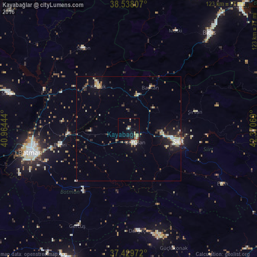
Analysis of Kayabağlar night lights 2016
Square area 10x10 km:
 0%
0%90-99
1.95%80-89
1.3%70-79
1.46%60-69
1.79%50-59
2.76%40-49
1.46%30-39
0.97%20-29
1.3%10-19
12.01%0-9
75%Square area 50x50 km:
0.32%90-99
1.04%80-89
0.82%70-79
0.44%60-69
0.5%50-59
0.76%40-49
1.09%30-39
1.15%20-29
1.44%10-19
3.64%0-9
88.8%Clear (daylight) street map image can be seen on geolist.org.
Map coordinates:
38° 32' 17.1" North, 40° 57' 52" East
37° 59' 9.6" North, 41° 40' 3.2" East
37° 25' 47" North, 42° 22' 14.5" East
Some cities around Kayabağlar sort by population:
• Batman
48.2 km =30 mi,  256°
256°
• Siirt
24.8 km =15.4 mi,  104°
104°
• Kurtalan
6.9 km =4.3 mi,  167°
167°
• Kozluk
28.2 km =17.5 mi,  323°
323°
• Sason
44 km =27.3 mi,  329°
329°
• Baykan
21.2 km =13.2 mi,  25°
25°
• Beşiri
34.3 km =21.3 mi, 256°
• Şirvan
32.5 km =20.2 mi,  74°
74°
308697 (p: 5,601)
Sources (retrieved 2019-11-25):
» Earth at Night: Flat Maps 2012, 2016