Zaghouan night lights from space
Night Light of Zaghouan (Zaghwān) from space (Tunisia) Src. Average luminocity for 10x10km area is 15.7465% and for 50x50km: 2.9482%.
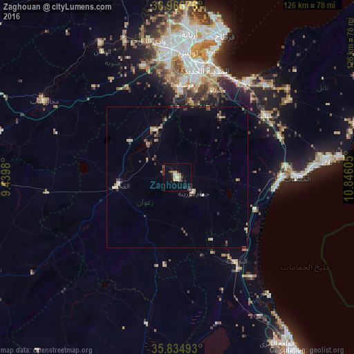
Analysis of Zaghouan night lights 2016
Square area 10x10 km:
 1.22%
1.22%90-99
1.75%80-89
3.67%70-79
2.45%60-69
1.4%50-59
1.05%40-49
1.92%30-39
1.92%20-29
1.22%10-19
6.12%0-9
77.27%Square area 50x50 km:
0.19%90-99
0.22%80-89
0.52%70-79
0.39%60-69
0.39%50-59
0.3%40-49
0.59%30-39
0.53%20-29
0.28%10-19
0.86%0-9
95.73%Clear (daylight) street map image can be seen on geolist.org.
Map coordinates:
36° 58' 0.3" North, 9° 26' 23.3" East
36° 24' 10.5" North, 10° 8' 34.5" East
35° 50' 5.7" North, 10° 50' 45.8" East
Some cities around Zaghouan sort by population:
• Ben Arous
39.7 km =24.7 mi,  10°
10°
• La Mohammedia
30.2 km =18.8 mi,  2°
2°
• Hammamet
42.4 km =26.3 mi,  90°
90°
• Hammam-Lif
40.3 km =25 mi,  26°
26°
• Radès
42.4 km =26.3 mi,  16°
16°
• La Sebala du Mornag
33.5 km =20.8 mi, 23°
• El Fahs
21.4 km =13.3 mi,  261°
261°
• Bou Arkoub
39.5 km =24.5 mi,  67°
67°
2464041 (p: 16,911)
Sources (retrieved 2019-11-25):
» Earth at Night: Flat Maps 2012, 2016