Ron Phibun night lights from space
Night Light of Ron Phibun (Nakhon Si Thammarat) from space (Thailand) Src. Average luminocity for 10x10km area is 8.6384% and for 50x50km: 5.9036%.

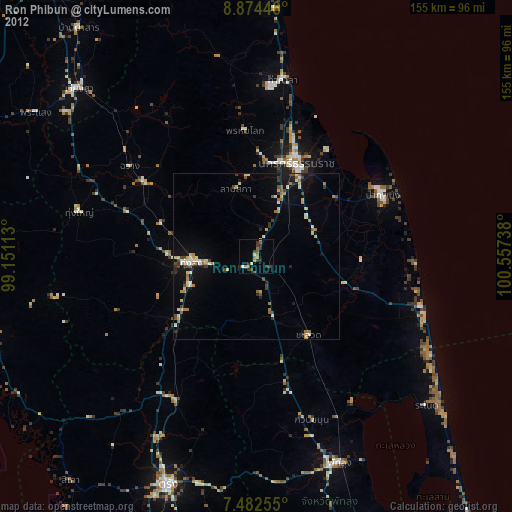
Analysis of Ron Phibun night lights 2016
Square area 10x10 km:
 0%
0%90-99
0%80-89
0.41%70-79
0.41%60-69
2.89%50-59
2.07%40-49
4.75%30-39
1.86%20-29
2.89%10-19
0.41%0-9
84.3%Square area 50x50 km:
0.45%90-99
0.49%80-89
0.75%70-79
0.66%60-69
0.97%50-59
0.95%40-49
0.93%30-39
0.86%20-29
2.2%10-19
4.71%0-9
87.02%Clear (daylight) street map image can be seen on geolist.org.
Map coordinates:
8° 52' 28.1" North, 99° 9' 4.1" East
8° 10' 44.8" North, 99° 51' 15.3" East
7° 28' 57.2" North, 100° 33' 26.6" East
Some cities around Ron Phibun sort by population:
• Nakhon Si Thammarat
30.9 km =19.2 mi,  23°
23°
• Phatthalung
67.1 km =41.7 mi,  158°
158°
• Thung Song
19.2 km =11.9 mi,  265°
265°
• Pak Phanang
42.8 km =26.6 mi,  63°
63°
• Ranot
68.1 km =42.3 mi,  130°
130°
• Huai Yot
49.6 km =30.8 mi,  209°
209°
• Chawang
47.3 km =29.4 mi,  305°
305°
• Tham Phannara
57.2 km =35.5 mi,  297°
297°
1150921 (p: 26,621)
Sources (retrieved 2019-11-25):
» Earth at Night: Flat Maps 2012, 2016