Huai Yot night lights from space
Night Light of Huai Yot (Trang) from space (Thailand) Src. Average luminocity for 10x10km area is 9.5124% and for 50x50km: 3.4327%.
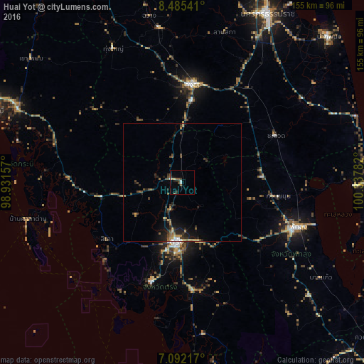
Analysis of Huai Yot night lights 2016
Square area 10x10 km:
 0.21%
0.21%90-99
1.86%80-89
0.83%70-79
0.83%60-69
1.03%50-59
2.48%40-49
1.65%30-39
1.86%20-29
2.07%10-19
1.45%0-9
85.74%Square area 50x50 km:
0.16%90-99
0.21%80-89
0.36%70-79
0.51%60-69
0.53%50-59
0.61%40-49
0.64%30-39
0.85%20-29
1.23%10-19
2.08%0-9
92.82%Clear (daylight) street map image can be seen on geolist.org.
Map coordinates:
8° 29' 7.5" North, 98° 55' 53.7" East
7° 47' 21.7" North, 99° 38' 4.9" East
7° 5' 31.8" North, 100° 20' 16.2" East
Some cities around Huai Yot sort by population:
• Trang
26 km =16.2 mi,  185°
185°
• Phatthalung
52.4 km =32.6 mi,  111°
111°
• Thung Song
42 km =26.1 mi,  6°
6°
• Ron Phibun
49.6 km =30.8 mi,  29°
29°
• Kantang
44.7 km =27.8 mi,  197°
197°
• Chawang
72.2 km =44.9 mi,  348°
348°
• Saladan
68.8 km =42.8 mi,  253°
253°
• Ko Lanta
66.8 km =41.5 mi,  244°
244°
1153241 (p: 16,586)
Sources (retrieved 2019-11-25):
» Earth at Night: Flat Maps 2012, 2016