Pho Thong night lights from space
Night Light of Pho Thong (Ang Thong) from space (Thailand) Src. Average luminocity for 10x10km area is 31.1798% and for 50x50km: 20.8923%.
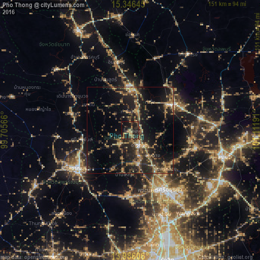
Analysis of Pho Thong night lights 2016
Square area 10x10 km:
 0%
0%90-99
0%80-89
3.93%70-79
5.79%60-69
6.2%50-59
4.96%40-49
6.2%30-39
9.09%20-29
23.35%10-19
34.92%0-9
5.58%Square area 50x50 km:
0.42%90-99
0.67%80-89
3.15%70-79
3%60-69
4.43%50-59
3.59%40-49
4.12%30-39
5.75%20-29
9.28%10-19
18.24%0-9
47.35%Clear (daylight) street map image can be seen on geolist.org.
Map coordinates:
15° 20' 47.2" North, 99° 42' 20.4" East
14° 40' 2.3" North, 100° 24' 31.6" East
13° 59' 9.8" North, 101° 6' 42.9" East
Some cities around Pho Thong sort by population:
• Lop Buri
30.1 km =18.7 mi,  61°
61°
• Sing Buri
24.5 km =15.2 mi,  358°
358°
• Phak Hai
23.7 km =14.7 mi,  190°
190°
• Wiset Chaichan
11.1 km =6.9 mi,  223°
223°
• Bang Racham
26.9 km =16.7 mi,  338°
338°
• Ban Thai Tan
9.9 km =6.2 mi,  121°
121°
• Ang Thong
10 km =6.2 mi,  151°
151°
• Chaiyo
6.5 km =4 mi,  81°
81°
1607579 (p: 12,200)
Sources (retrieved 2019-11-25):
» Earth at Night: Flat Maps 2012, 2016