Bang Racham night lights from space
Night Light of Bang Racham (Sing Buri) from space (Thailand) Src. Average luminocity for 10x10km area is 17.7252% and for 50x50km: 13.1338%.
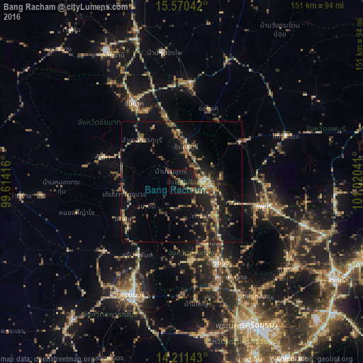
Analysis of Bang Racham night lights 2016
Square area 10x10 km:
 0%
0%90-99
0.21%80-89
2.27%70-79
1.86%60-69
3.31%50-59
4.75%40-49
1.03%30-39
3.1%20-29
5.99%10-19
31.61%0-9
45.87%Square area 50x50 km:
0.17%90-99
0.46%80-89
1.78%70-79
1.54%60-69
2.8%50-59
2.43%40-49
2.86%30-39
3.34%20-29
3.57%10-19
12.03%0-9
69.01%Clear (daylight) street map image can be seen on geolist.org.
Map coordinates:
15° 34' 13.5" North, 99° 36' 51" East
14° 53' 31.2" North, 100° 19' 2.2" East
14° 12' 41.1" North, 101° 1' 13.5" East
Some cities around Bang Racham sort by population:
• Sing Buri
9.4 km =5.8 mi,  92°
92°
• Wiset Chaichan
33.2 km =20.6 mi,  176°
176°
• Doembang Nangbuat
24.2 km =15 mi,  254°
254°
• Ban Thai Tan
35.2 km =21.9 mi,  148°
148°
• Ang Thong
36.8 km =22.9 mi,  156°
156°
• Ban Sam Chuk
29.1 km =18.1 mi,  235°
235°
• Chaiyo
29 km =18 mi, 145°
• Pho Thong
26.9 km =16.7 mi, 158°
1619281 (p: 15,313)
Sources (retrieved 2019-11-25):
» Earth at Night: Flat Maps 2012, 2016