Phak Hai night lights from space
Night Light of Phak Hai (Phra Nakhon Si Ayutthaya) from space (Thailand) Src. Average luminocity for 10x10km area is 21.0671% and for 50x50km: 25.9791%.
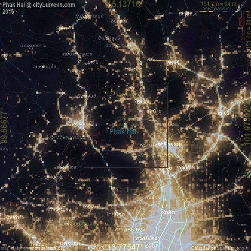
Analysis of Phak Hai night lights 2016
Square area 10x10 km:
 0%
0%90-99
0.22%80-89
1.95%70-79
2.16%60-69
2.16%50-59
6.49%40-49
5.84%30-39
5.84%20-29
6.49%10-19
30.74%0-9
38.1%Square area 50x50 km:
1.05%90-99
1.14%80-89
4.81%70-79
4.21%60-69
5.51%50-59
4.65%40-49
4.96%30-39
6.2%20-29
10.85%10-19
15.52%0-9
41.1%Clear (daylight) street map image can be seen on geolist.org.
Map coordinates:
15° 8' 13.8" North, 99° 40' 0.4" East
14° 27' 26.5" North, 100° 22' 11.6" East
13° 46' 31.7" North, 101° 4' 22.9" East
Some cities around Phak Hai sort by population:
• Phra Nakhon Si Ayutthaya
25.2 km =15.7 mi,  117°
117°
• Wiset Chaichan
15.6 km =9.7 mi,  347°
347°
• Bang Ban
15.5 km =9.6 mi,  126°
126°
• Nakhon Luang
25.7 km =16 mi,  88°
88°
• Ban Thai Tan
22.2 km =13.8 mi,  34°
34°
• Ang Thong
17.1 km =10.6 mi, 31°
• Chaiyo
26.6 km =16.5 mi,  23°
23°
• Pho Thong
23.7 km =14.7 mi,  10°
10°
1607865 (p: 19,386)
Sources (retrieved 2019-11-25):
» Earth at Night: Flat Maps 2012, 2016