Phanom Thuan night lights from space
Night Light of Phanom Thuan (Kanchanaburi) from space (Thailand) Src. Average luminocity for 10x10km area is 9.9437% and for 50x50km: 14.4406%.
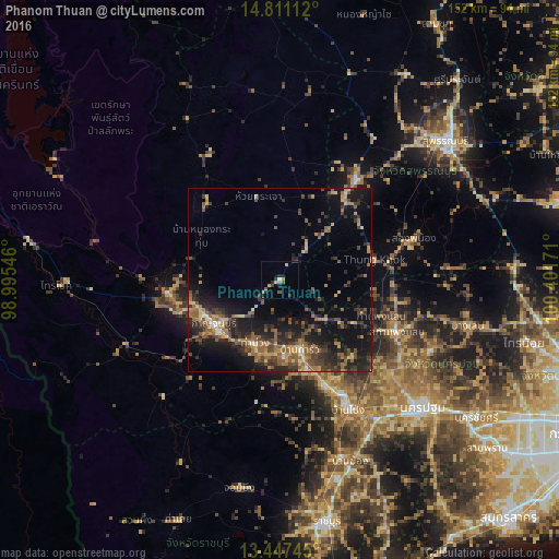
Analysis of Phanom Thuan night lights 2016
Square area 10x10 km:
 0%
0%90-99
0.87%80-89
1.08%70-79
1.95%60-69
2.16%50-59
2.6%40-49
0%30-39
2.81%20-29
3.9%10-19
1.08%0-9
83.55%Square area 50x50 km:
0.29%90-99
0.58%80-89
1.78%70-79
1.77%60-69
2.73%50-59
3.67%40-49
3.22%30-39
3.83%20-29
5.87%10-19
11.21%0-9
65.05%Clear (daylight) street map image can be seen on geolist.org.
Map coordinates:
14° 48' 40" North, 98° 59' 43.7" East
14° 7' 49.1" North, 99° 41' 54.9" East
13° 26' 50.8" North, 100° 24' 6.2" East
Some cities around Phanom Thuan sort by population:
• Nakhon Pathom
50.8 km =31.6 mi,  132°
132°
• Kanchanaburi
21.4 km =13.3 mi,  229°
229°
• Ban Pong
39.9 km =24.8 mi,  151°
151°
• Tha Maka
26.6 km =16.5 mi,  163°
163°
• Photharam
51.4 km =31.9 mi, 161°
• Tha Muang
19.8 km =12.3 mi,  198°
198°
• Bang Len
52.4 km =32.6 mi,  103°
103°
• Bo Phloi
29.4 km =18.3 mi,  317°
317°
1151446 (p: 12,469)
Sources (retrieved 2019-11-25):
» Earth at Night: Flat Maps 2012, 2016