Phanom Sarakham night lights from space
Night Light of Phanom Sarakham (Chachoengsao) from space (Thailand) Src. Average luminocity for 10x10km area is 38.8802% and for 50x50km: 19.4394%.
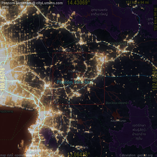
Analysis of Phanom Sarakham night lights 2016
Square area 10x10 km:
 1.86%
1.86%90-99
2.27%80-89
9.5%70-79
2.69%60-69
9.09%50-59
7.02%40-49
8.26%30-39
11.16%20-29
10.95%10-19
30.99%0-9
6.2%Square area 50x50 km:
0.74%90-99
0.69%80-89
2.5%70-79
2.44%60-69
2.71%50-59
3.8%40-49
4.22%30-39
6.5%20-29
7.84%10-19
20.04%0-9
48.52%Clear (daylight) street map image can be seen on geolist.org.
Map coordinates:
14° 25' 50.5" North, 100° 38' 44.7" East
13° 44' 55.4" North, 101° 20' 56" East
13° 3' 53.1" North, 102° 3' 7.2" East
Some cities around Phanom Sarakham sort by population:
• Chachoengsao
30.7 km =19.1 mi,  257°
257°
• Prachin Buri
33.6 km =20.9 mi,  3°
3°
• Bang Pakong
44.7 km =27.8 mi,  239°
239°
• Phanat Nikhom
38.1 km =23.7 mi,  207°
207°
• Kabin Buri
45.7 km =28.4 mi,  60°
60°
• Phan Thong
41.5 km =25.8 mi,  221°
221°
• Bang Khla
15.5 km =9.6 mi, 258°
• Bang Nam Priao
33.8 km =21 mi,  288°
288°
1607801 (p: 16,057)
Sources (retrieved 2019-11-25):
» Earth at Night: Flat Maps 2012, 2016