Long night lights from space
Night Light of Long (Phrae) from space (Thailand) Src. Average luminocity for 10x10km area is 7.0714% and for 50x50km: 3.1743%.
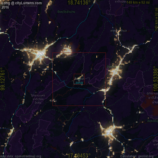
Analysis of Long night lights 2016
Square area 10x10 km:
 0%
0%90-99
0%80-89
0%70-79
1.73%60-69
2.81%50-59
1.52%40-49
0.43%30-39
2.81%20-29
3.68%10-19
0.65%0-9
86.36%Square area 50x50 km:
0.1%90-99
0.43%80-89
0.54%70-79
0.34%60-69
0.29%50-59
0.42%40-49
0.55%30-39
0.7%20-29
0.89%10-19
2.62%0-9
93.12%Clear (daylight) street map image can be seen on geolist.org.
Map coordinates:
18° 44' 28.9" North, 99° 7' 39.4" East
18° 4' 27.2" North, 99° 49' 50.6" East
17° 24' 16.3" North, 100° 32' 1.9" East
Some cities around Long sort by population:
• Lampang
43.2 km =26.8 mi,  304°
304°
• Uttaradit
57.2 km =35.5 mi,  150°
150°
• Phrae
33.7 km =20.9 mi,  76°
76°
• Si Satchanalai
62.4 km =38.8 mi,  186°
186°
• Sawankhalok
84.3 km =52.4 mi,  179°
179°
• Thoen
82.8 km =51.4 mi,  231°
231°
• Den Chai
25.5 km =15.8 mi,  113°
113°
• Rong Kwang
59.2 km =36.8 mi,  60°
60°
1152322 (p: 11,802)
Sources (retrieved 2019-11-25):
» Earth at Night: Flat Maps 2012, 2016