Doembang Nangbuat night lights from space
Night Light of Doembang Nangbuat (Suphanburi) from space (Thailand) Src. Average luminocity for 10x10km area is 13.2996% and for 50x50km: 6.7269%.
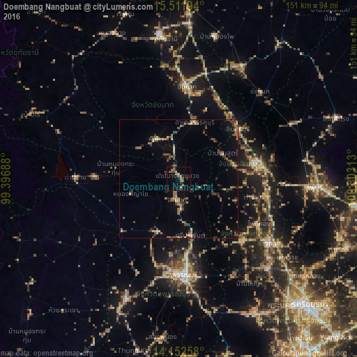
Analysis of Doembang Nangbuat night lights 2016
Square area 10x10 km:
 0%
0%90-99
0%80-89
0.83%70-79
0.41%60-69
7.23%50-59
3.72%40-49
1.86%30-39
0.83%20-29
0.83%10-19
2.69%0-9
81.61%Square area 50x50 km:
0.06%90-99
0.22%80-89
0.63%70-79
0.76%60-69
1.52%50-59
1.5%40-49
1.47%30-39
1.69%20-29
1.38%10-19
2.31%0-9
88.45%Clear (daylight) street map image can be seen on geolist.org.
Map coordinates:
15° 30' 43" North, 99° 23' 48.8" East
14° 49' 60" North, 100° 6' 0" East
14° 9' 9.3" North, 100° 48' 11.3" East
Some cities around Doembang Nangbuat sort by population:
• Suphan Buri
40 km =24.9 mi,  176°
176°
• Sing Buri
33.3 km =20.7 mi,  79°
79°
• Wiset Chaichan
36.9 km =22.9 mi,  136°
136°
• Chai Nat
39.3 km =24.4 mi,  3°
3°
• Bang Racham
24.2 km =15 mi,  74°
74°
• Ban Sam Chuk
10.1 km =6.3 mi, 182°
• Chaiyo
43.3 km =26.9 mi,  113°
113°
• Pho Thong
38 km =23.6 mi,  119°
119°
1610911 (p: 14,671)
Sources (retrieved 2019-11-25):
» Earth at Night: Flat Maps 2012, 2016