Ban Sam Chuk night lights from space
Night Light of Ban Sam Chuk (Suphanburi) from space (Thailand) Src. Average luminocity for 10x10km area is 20.5475% and for 50x50km: 7.889%.
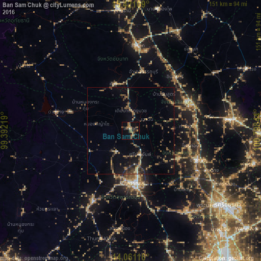
Analysis of Ban Sam Chuk night lights 2016
Square area 10x10 km:
 0%
0%90-99
0.83%80-89
0.83%70-79
4.34%60-69
6.2%50-59
6.61%40-49
2.07%30-39
5.79%20-29
3.31%10-19
7.02%0-9
63.02%Square area 50x50 km:
0.06%90-99
0.21%80-89
0.82%70-79
0.89%60-69
1.56%50-59
1.41%40-49
1.85%30-39
2.29%20-29
2.33%10-19
4.58%0-9
83.99%Clear (daylight) street map image can be seen on geolist.org.
Map coordinates:
15° 25' 15.9" North, 99° 23' 31.9" East
14° 44' 31.9" North, 100° 5' 43.1" East
14° 3' 40.2" North, 100° 47' 54.4" East
Some cities around Ban Sam Chuk sort by population:
• Suphan Buri
29.9 km =18.6 mi,  174°
174°
• Sing Buri
37 km =23 mi,  64°
64°
• Wiset Chaichan
30.9 km =19.2 mi,  122°
122°
• Bang Racham
29.1 km =18.1 mi, 55°
• Doembang Nangbuat
10.1 km =6.3 mi,  2°
2°
• Ang Thong
42.1 km =26.2 mi,  113°
113°
• Chaiyo
40.8 km =25.4 mi,  100°
100°
• Pho Thong
34.7 km =21.6 mi, 103°
1613534 (p: 13,438)
Sources (retrieved 2019-11-25):
» Earth at Night: Flat Maps 2012, 2016