Chon Daen night lights from space
Night Light of Chon Daen (Phetchabun) from space (Thailand) Src. Average luminocity for 10x10km area is 5.5785% and for 50x50km: 2.7581%.
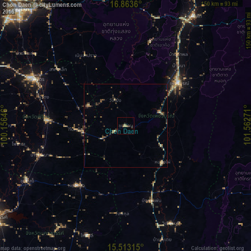
Analysis of Chon Daen night lights 2016
Square area 10x10 km:
 0%
0%90-99
0%80-89
1.65%70-79
0.83%60-69
0.83%50-59
0.83%40-49
0%30-39
3.31%20-29
1.24%10-19
0.83%0-9
90.5%Square area 50x50 km:
0%90-99
0.1%80-89
0.56%70-79
0.3%60-69
0.23%50-59
0.41%40-49
1.07%30-39
0.98%20-29
0.73%10-19
0.46%0-9
95.16%Clear (daylight) street map image can be seen on geolist.org.
Map coordinates:
16° 51' 49" North, 100° 9' 23.3" East
16° 11' 22.3" North, 100° 51' 34.5" East
15° 30' 47.3" North, 101° 33' 45.8" East
Some cities around Chon Daen sort by population:
• Phetchabun
41 km =25.5 mi,  51°
51°
• Phichit
61.3 km =38.1 mi,  297°
297°
• Nong Phai
30.9 km =19.2 mi,  135°
135°
• Taphan Hin
47.1 km =29.3 mi,  274°
274°
• Bang Mun Nak
54.4 km =33.8 mi,  250°
250°
• Thap Khlo
28.3 km =17.6 mi,  263°
263°
• Nong Bua
46.5 km =28.9 mi,  218°
218°
• Wang Sai Phun
40.8 km =25.4 mi, 302°
1611106 (p: 17,567)
Sources (retrieved 2019-11-25):
» Earth at Night: Flat Maps 2012, 2016