Ban Tak night lights from space
Night Light of Ban Tak (Tak) from space (Thailand) Src. Average luminocity for 10x10km area is 20.5476% and for 50x50km: 4.9962%.
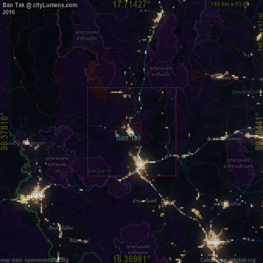
Analysis of Ban Tak night lights 2016
Square area 10x10 km:
 0.43%
0.43%90-99
2.16%80-89
6.71%70-79
2.6%60-69
2.6%50-59
0.43%40-49
5.19%30-39
2.38%20-29
3.46%10-19
6.93%0-9
67.1%Square area 50x50 km:
0.28%90-99
0.28%80-89
1.17%70-79
0.85%60-69
0.43%50-59
0.47%40-49
1.21%30-39
1.09%20-29
1.3%10-19
3.11%0-9
89.8%Clear (daylight) street map image can be seen on geolist.org.
Map coordinates:
17° 42' 51.4" North, 98° 22' 41.4" East
17° 2' 35.7" North, 99° 4' 52.6" East
16° 22' 11.3" North, 99° 47' 3.9" East
Some cities around Ban Tak sort by population:
• Kamphaeng Phet
77.9 km =48.4 mi,  143°
143°
• Myawadi, MM
72.5 km =45 mi,  237°
237°
• Mae Sot
65.7 km =40.8 mi, 236°
• Ban Na
69.3 km =43.1 mi,  92°
92°
• Tak
20 km =12.4 mi,  165°
165°
• Thoen
64.9 km =40.3 mi,  12°
12°
• Mae Ramat
60.4 km =37.5 mi,  263°
263°
• Ban Dan Lan Hoi
52.6 km =32.7 mi, 94°
1154677 (p: 18,384)
Sources (retrieved 2019-11-25):
» Earth at Night: Flat Maps 2012, 2016