Ban Ko Kaeo night lights from space
Night Light of Ban Ko Kaeo (Phuket) from space (Thailand) Src. Average luminocity for 10x10km area is 62.0806% and for 50x50km: 16.7992%.
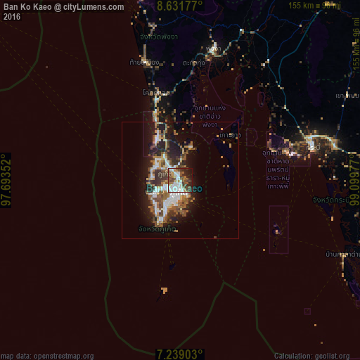
Analysis of Ban Ko Kaeo night lights 2016
Square area 10x10 km:
 16.53%
90-99
19.01%80-89
0.83%70-79
5.17%60-69
7.23%50-59
8.26%40-49
15.08%30-39
7.85%20-29
10.95%10-19
9.09%0-9
0%Square area 50x50 km:
2.95%90-99
3.13%80-89
0.93%70-79
1.46%60-69
2.55%50-59
3.27%40-49
3.54%30-39
2.42%20-29
4.34%10-19
9.49%0-9
65.92%Clear (daylight) street map image can be seen on geolist.org.
Map coordinates:
8° 37' 54.4" North, 97° 41' 36.7" East
7° 56' 9.6" North, 98° 23' 47.9" East
7° 14' 20.5" North, 99° 5' 59.2" East
Some cities around Ban Ko Kaeo sort by population:
• Phuket
5.1 km =3.2 mi,  178°
178°
• Ban Talat Yai
5.7 km =3.5 mi, 176°
• Wichit
5.3 km =3.3 mi,  193°
193°
• Kathu
7.3 km =4.5 mi,  253°
253°
• Ban Ratsada
3 km =1.9 mi,  167°
167°
• Ban Talat Nua
5.8 km =3.6 mi, 192°
• Ban Chalong
12 km =7.5 mi,  212°
212°
• Patong
11.9 km =7.4 mi, 248°
1156836 (p: 10,136)
Sources (retrieved 2019-11-25):
» Earth at Night: Flat Maps 2012, 2016