Ban Karon night lights from space
Night Light of Ban Karon (Phuket) from space (Thailand) Src. Average luminocity for 10x10km area is 57.3905% and for 50x50km: 14.4535%.
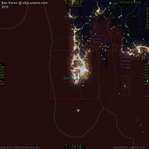
Analysis of Ban Karon night lights 2016
Square area 10x10 km:
 14.05%
90-99
13.22%80-89
2.48%70-79
2.89%60-69
7.02%50-59
21.07%40-49
12.19%30-39
1.45%20-29
8.68%10-19
16.32%0-9
0.62%Square area 50x50 km:
2.79%90-99
2.91%80-89
0.76%70-79
1.14%60-69
1.94%50-59
2.85%40-49
3.22%30-39
2.19%20-29
3.73%10-19
6.89%0-9
71.59%Clear (daylight) street map image can be seen on geolist.org.
Map coordinates:
8° 32' 37.1" North, 97° 35' 43.4" East
7° 50' 51.7" North, 98° 17' 54.6" East
7° 9' 2.1" North, 99° 0' 5.9" East
Some cities around Ban Karon sort by population:
• Phuket
12 km =7.5 mi,  66°
66°
• Ban Talat Yai
11.9 km =7.4 mi, 69°
• Wichit
10.6 km =6.6 mi,  64°
64°
• Kathu
8.7 km =5.4 mi,  26°
26°
• Ban Talat Nua
10.4 km =6.5 mi, 66°
• Ban Chalong
4.5 km =2.8 mi,  94°
94°
• Patong
5.4 km =3.4 mi,  357°
357°
• Rawai
8.1 km =5 mi,  158°
158°
1157249 (p: 7,094)
Sources (retrieved 2019-11-25):
» Earth at Night: Flat Maps 2012, 2016